Welcome to the
St Mary Redcliffe Boys'
School
Pre. 1970
History Project Website
Redcliffe Vicarages & Rail Tunnel
(in
relation to St Mary Redcliffe Boys' School)
This page is divided into 2 sections:
The
Vicarages | Redcliffe Rail Tunnel
To
leave
your comments / memories,
click to Memory Lane
WANTED!
- If you have any other pre. 1970
images, memories, stories or other historical information about the Vicarages
or rail tunnel relating to St Mary Redcliffe Boys'
School that could be displayed on this page (with a credit to you of course)
please commit them to an email now and .
radical_solutions (at) hotmail (dot)
com
Two St Mary Redcliffe
Vicarages
(important in School's History)
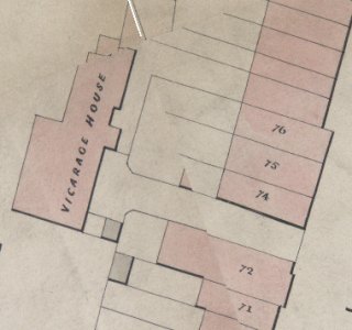
Map shows original Vicarage building (b 1701)
in circa 1850 with wide
entrance on to RH for access. The address
was No. 73 Redcliffe Hill.
Looking down the driveway from the Vicarage
towards
Redcliffe Hill, pic shows "then and now" views
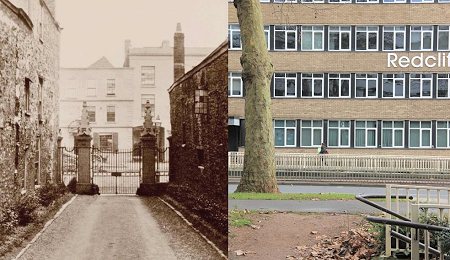
The original Vicarage was demolished in circa 1868 to make way for the new rail tunnel. The new Vicarage was built after the tunnel's completion. circa 1872 and its location moved north (much closer to the school) to avoid the tunnel. The driveway and large front garden of the new Vicarage now had the tunnel directly beneath.
Access to the new Vicarage was from Guinea Street (much further to walk to and from the Church) so a new alleyway was provided, retaining the original quicker route to the Church. See map, circa 1930 up this page, to see position of an alleyway leading to the re-built Vicarage and how it joined to other footpaths around the new grounds. The Vicarage was demolished in around 1939, only the alleyway remained for school use.
Aerial photo of school in 1946
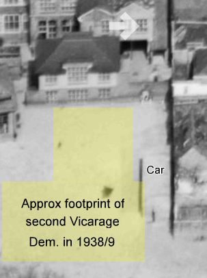
Note "car" marks appox position of vehicle shown
in picture below,
arrow indicates window in old school building
that's partly visible
View of main school building down the side of
the NEW Vicarage (built circa 1870).
Chimney shown is that above "H"
on "keyed" view shown at the top of main
page.

Click
image to view full Vicarage picture
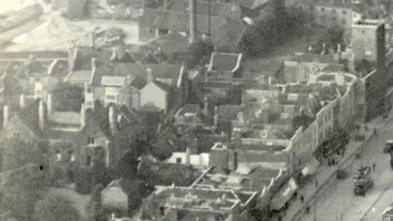
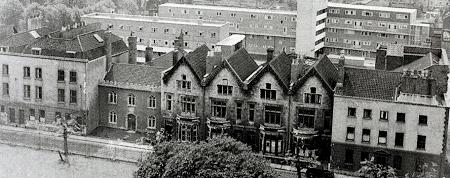
A (fuzzy) aerial view around 1930 - Shot
Tower top right this time.
Vicarage shown bottom left backing
onto school, see better picture above.
click image to
enlarge
Note rank of single storey
shops with awnings on Redcliffe Hill.
The back wall of the school
(left center of pic) appears blank?
Mysterious as there
were windows? - (see pic below)
Another AV (1934) showing how close the vicarage
was to the back of
the school. Back wall of the school clearly
has the window in this picture
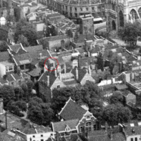
Note: Parish Hall - bottom center | Shot Tower and Church - top right
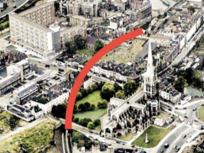
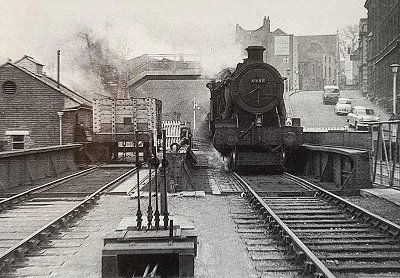
Redcliffe
Rail
Tunnel started in 1868
(Opened in 1870, last train ran
1964)
Redcliffe Tunnel is 282 yards long and carried 2 tracks. It's construction involved
the demolition of the original Vicarage and the removal and re-internment of Redcliffe
Church's
graveyard to a site, still used today, opposite Arnos Vale cemetery.
Two years later in 1872 the church tower, which had been struck by lightning in 1446, was finally repaired after 400+ years. One might speculate that money for the repair may have come from reparations paid by the builders of the tunnel. A case of something deep in the ground paying for something high in the air!
Three shops and a school access were built over the railway tunnel where it crossed Redcliffe Hill replacing existing the shops from no 71 to 76. (see map in Vicarage section of this page) The tunnel could not withstand the weight of a 2 storey building. (see map circa 1930 at top of main page for tunnel route)
Closer view of the "out of place" single storey shops on Redcliffe Hill
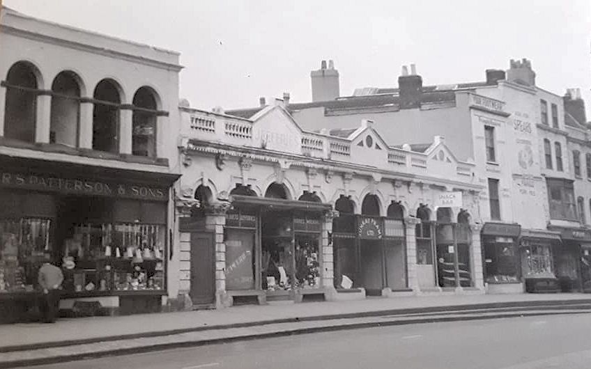
click image to
enlarge
Note part of school roof
/ buildings in background,
School's third access
point via single arch to left of rank
It is interesting that for the "landed gentry" homes (see below) rebuilt opposite the church (including Samuel Plimsol's birth place 1824), more money was found to make the foundations much stronger allowing second & third storeys, nothing really changes!
The broken facade of Colston Parade, trouble underground?
This picture, circa 1965, pinpoints each end
of the rail tunnel / POI
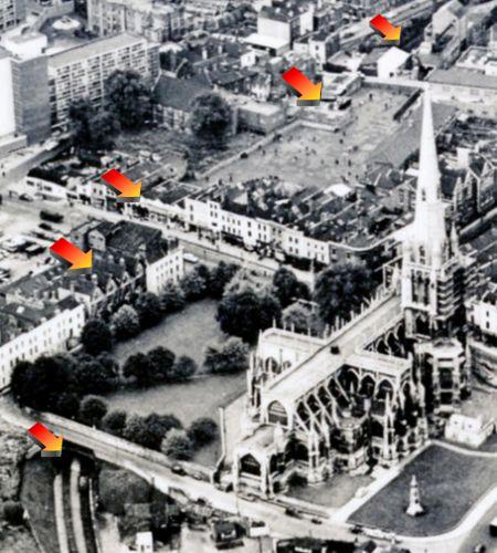
Note kids in playground, I could have been
one of those dots!
Protrusion into playground
directly over tunnel route - purpose?
Victorian "Gap"
in Georgian facade facing the Church and the
single storey shops on
RH both marking where the tunnel runs.
Pictures show the Baltic Wharf end of tunnel circa 1960
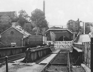
Note Guinea Street houses just visible center right
Picture shows Church end of tunnel circa 1980
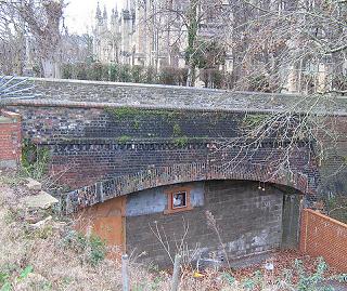
Note raised ground level only leaves approx. the
top half
of tunnel entrance visible, Church in background,
ventilation
fan in the bricked up entrance?
Read more about the rail line that included the tunnel here
WANTED!
- If you have any other pre. 1970
images, memories, stories or other historical information about the Vicarages
or rail tunnel relating to St Mary Redcliffe Boys'
School that could be displayed on this page (with a credit to you of course)
please commit them to an email now and .
radical_solutions (at) hotmail (dot)
com